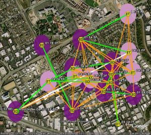
Using a mixture of a Wifi Mesh on top of Google Earth can help give a birds eye view of how a wireless network mesh is running. As seen in the picture above the SkyControl software collects node data with GPS coordinates and link states. This then creates a satellite based image in Google showing the status of the mesh.
Skycontrol is used in a NOC (Network Operations Centre) and allows you to manage and see a whole network based on a map system. This eliminates the need for manual mapping techniques and can give a real time status to the engineers.
Overall this could be a valuable took for those running a wifi mesh and help track problems and provide accurate maps to find and solve problems with in a short period of time.
Via: SkyPilot


Speak Your Mind
You must be logged in to post a comment.